


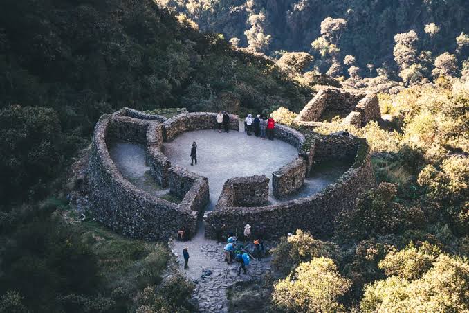
After descending from Warmiwañusca, your body craves flat ground. There is none. The classic 4-day trek sleeps in Pacaymayo, and the following morning it climbs again. At around 3,750 meters, before the second pass, the trail meets a building unlike the others: an oval enclosure, almost a stone horseshoe, open to the valley.
That is Runkurakay. It is also spelled Runkuraqay. It is not a settlement like Patallacta or a terraced sanctuary like Wiñay Wayna. It is a hillside tambo: a stopover, relay point, and lookout on the highest section of the route to Machu Picchu.
Where it is and what the name means
Runkurakay sits on the southern slope of the mountain of the same name, within the Historic Sanctuary of Machu Picchu, in the district of Machupicchu, Urubamba Province. It lies above the Pacaymayo Valley and below Runkurakay Pass, which stands at roughly 4,000 meters.
Quechua explains more than the sign. Runku means basket. Raqay means shelter, ruined house, or shed. Basket-house, round shelter. Another interpretation uses runtu, meaning egg, because of the elliptical layout of the main building. Both describe the same thing: an enclosed structure, not a grid of courtyards.
It is visited on the third day of the Classic Inca Trail, on the climb out of the Pacaymayo campsite. The short 2-day trek does not pass through here. It starts farther down, at kilometer 104.
History
The complex forms part of the 15th-century road network, when the Inca state expanded the Qhapaq Ñan toward Antisuyo and the sanctuary of Machu Picchu. There is no plaque bearing Pachacútec’s name. There is a stone tambo at the exact point where the trail leaves one valley and tackles the next pass. That logic is enough.
The chasquis ran short stretches and delivered their message at the next post. A high-altitude tambo is not a tourist lodge. It is a relay station: shelter, fire, storage, and a view of those climbing up. Runkurakay covers the stretch between Pacaymayo and Sayacmarca. Whoever controls that slope can see the valley floor and the approach to the pass.
Hiram Bingham arrived in April 1915, four years after Machu Picchu. Paul Fejos returned in 1940. The site was extensively restored in the late 1990s. That is why the oval is so clear today: it is not a moss-covered pile. It is a floor plan.
Architecture
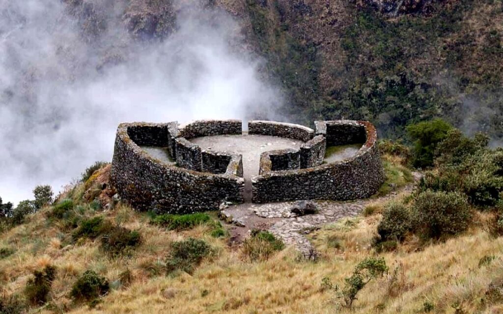
What sets it apart from the rest of the route is its layout. Inca architecture usually features rectangular enclosures. Here, the main structure is circular or slightly elliptical, around twenty meters across, with a central courtyard and rooms around it.
You enter through a narrow passage, about 4.5 meters long by 2.2 meters wide. Inside, concentric walls divide the space into several rooms: some larger, others very small. The courtyard faces northeast, toward the valley. There are six enclosures around it. Two flank the entrance and have windows. The walls feature niches and trapezoidal openings, the typical Inca design used to lighten the lintel and withstand earthquakes.
The stone is slate and gray granite from the mountain. Double-faced walls with fill, set into the slope. It is not the fine masonry of a temple in Cusco. It is mountain construction: stable, compact, built for wind and rain.
About twenty meters to the southeast, there is a rectangular building measuring roughly ten meters. It also has niches. It completes the tambo: the oval was not alone. Below, there is a low platform with small rooms on either side. The complex is small. You can walk through it in just a few minutes. Its form and the emptiness of the valley do the rest.
The niches have led some to suggest a ritual use. It may have had one. At a high-pass tambo, worship does not need a large plaza. A niche and a courtyard are enough. What the building demonstrates, without too much speculation, is visual control and a sheltered interior. The Pacaymayo mist rolls in without warning. A curved wall encloses better than a row of open houses.
What it was used for
Three functions fit within this layout:
Tambo. A place to sleep, eat, and leave supplies. The trail does not forgive a mountain-pass section without shelter.
Chasqui relay station. The state messenger service did not wait for the rain to stop. A post at 3,750 meters breaks up the day between the descent from Warmiwañusca and Sayacmarca.
Surveillance. From the oval, it is possible to see who is climbing from Pacaymayo and who is heading toward the pass. Willkaraqay does the same above Patallacta. Runkurakay does it over the second valley.
There are no productive terraces like those at Patallacta or Wiñay Wayna. This was not a place that fed a settlement. It supported a section of the trail.
What it looks like on the trek
You leave Pacaymayo in the cold. After the bridge over the river and a short climb, the tambo appears to the left of the trail, before your legs start demanding the pass. The guide usually gives you ten minutes. Enough time to enter the passage, see the courtyard, and not stop at just taking a photo of the curved wall.
Afterward, the trail continues uphill to Runkurakay Pass, descends toward Sayacmarca, and the day fills with stone. Anyone who confuses the site with the pass misses the building. The pass is the saddle. Runkurakay is the tambo before it.
If the group is short on time, this is the stop that gets skipped. Do not skip it. It is the only round enclosure on the route and the first one you walk inside after viewing Patallacta from above.
Frequently asked questions
What does Runkurakay mean?
In Quechua, it can be read as basket-house or round shelter (runku + raqay). It is also associated with the egg-like shape of the main building.
Is Runkurakay the pass or the ruins?
Both carry the name. The archaeological site is at around 3,750 meters. The pass, slightly higher up, is close to 4,000. First comes the tambo, then the saddle.
What was its function?
A trail tambo: a place for rest, chasqui relays, and visual control of the Pacaymayo Valley. It was not an agricultural center.
Why is it circular?
The oval layout is unusual on the route, where rectangular enclosures dominate. It encloses the courtyard, withstands the wind, and opens toward the valley. No longer theory is needed to explain its use.
On which day is it visited?
On day 3 of the classic 4-day Inca Trail, after leaving Pacaymayo. It is not included on the short 2-day trek.
Who recorded it?
Hiram Bingham in 1915. Paul Fejos in 1940. The visible restoration dates from the late 1990s.