


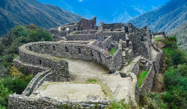
The trail descends from Runkurakay Pass, and the cloud forest begins to take over. To the left, a rocky spur juts out over the void. A single stone staircase climbs to the ridge. At the top, there is no round tambo like Runkurakay. There is a settlement pressed against the precipice: alleyways, structures on several levels, a small plaza, and the Aobamba Valley in the background.
That is Sayacmarca. It is also spelled Sayaqmarka. The name itself describes the place: a standing settlement, a settlement not easily reached.
Where it is and what it means
Sayacmarca is in the Historic Sanctuary of Machu Picchu, in the Machupicchu District, Urubamba Province. It sits on a spur at around 3,600 meters, southwest of Runkurakay Pass and before Phuyupatamarca. It overlooks two valleys: the Urubamba and the Aobamba.
In Quechua, sayaq means something standing, firm, dominant. Marka means settlement. A standing settlement or an inaccessible settlement. Bingham did not use that name. In 1915, he called it Cedrobamba, plain of the cedars, after the forest that stood there at the time. In 1940, Paul Fejos’s expedition named it Sayacmarca, which better describes the cliff.
The 4-day Classic Inca Trail visits it on the third day, after the tambo and Runkurakay Pass. The 2-day Short Inca Trail does not reach this point.
A little farther ahead, along the same section, lies Conchamarca (Qunchamarka), a smaller complex. It is not Sayacmarca. Guides usually point out the difference at the staircase.
History
The spur was heavily occupied in the 15th century, when the Inca state consolidated the ritual route to Machu Picchu. Some suggest there was an earlier settlement, later reused and expanded. What you walk through today is Inca construction: trapezoidal openings, channels, and walls that follow the rock.
It was not a valley city. It was a high post on the Qhapaq Ñan. Anyone entering Antisuyo along this ridge had to pass below that hill. A small settlement, with elite structures and ceremonial spaces, was enough to control the passage and accommodate those sent by the state.
Hiram Bingham explored it in April 1915, during the same expedition in which he recorded Runkurakay. He documented it and moved on. Twenty-five years later, Fejos cleared more of the site, measured it, and changed its name. Since then, visitors have entered the site by the same staircase they used.
Some travel accounts mention around two hundred occupants. It is not a census. It is a way of saying that this was neither a two-room tambo nor a citadel the size of Patallacta. It was a compact settlement, supplied partly from outside: there is barely enough room on the ridge for a large system of terraces.
Features of the complex
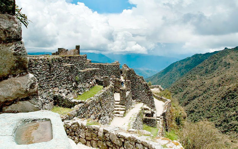
Its first defining feature is access. A single staircase carved into the slope, narrow, with the drop-off on one side. Around ninety steps, depending on who counts them. There is no other easy entrance. The name makes sense as you climb.
At the top, the layout divides into two complementary areas.
The ceremonial ridge. A curved or elliptical structure overlooks the precipice, with openings facing the valley. There are stone ritual baths or fountains. An irregular plaza, sometimes described as triangular, organizes the opposite end. A double jamb in one opening marks a structure that was not simply a passing kitchen.
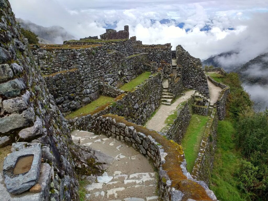
The residential maze. Narrow streets, structures on tiny terraces, and passageways that shift in elevation. Niches in the walls. Trapezoidal doorways. The masonry is mountain construction, set into the slope, not the fine cushioned stonework of a temple in Cusco.
Water runs through short channels. On a cliff with no broad farmland, the channel does not irrigate hectares. It carries spring water to the structures and the fountain. Phuyupatamarca, farther ahead, takes that idea further. Here, you can already see the concept.
Anyone looking for terraces like those at Wiñay Wayna is in the wrong place. Sayacmarca lives off its rocky spur. Food and corn would have come from below or from nearby complexes. What the site produces is control: a view, a single entrance, and shelter for officials and state travelers.
What it was used for
Three functions can be read clearly from the layout.
Trail control. There is only one way up. Anyone arriving can be seen. Anyone not meant to pass cannot enter without being noticed.
Accommodation. There were enough structures for a permanent staff and for travelers heading to Machu Picchu. A ridge lodge, not a market.
Worship. The platform, baths, and ridge structure are not a storehouse. Along the sacred route, the watch post also faced the apus. The Aobamba Valley and the Vilcabamba peaks lie ahead.
Patallacta produces in the valley. Runkurakay serves as a relay point on the hill. Sayacmarca stands on the cliff and controls the passage. All three were part of the same system, each with a different role.
What it looks like on the trek
The group arrives with the effort of the second pass in their legs. The main trail does not cross through the settlement: it passes alongside it, leaving the staircase as a detour. It is worth taking. Ten to fifteen minutes uphill is enough to walk through the passageway, look out over the drop, and descend carefully. Wet stone is slippery. The cliff does not forgive a photo taken with your back to the edge.
Afterward, the trail enters a short tunnel, then cloud forest and a ridge toward Phuyupatamarca. Day 3 has the most sites. Sayacmarca is the first one you explore as a citadel rather than a tambo.
Frequently asked questions
Do you have to climb the staircase, or can you see it just as well from the trail?
From the trail, you only see the spur. The settlement is at the top. If you do not climb the steps, you do not enter it. They are narrow, with the drop-off on one side: if heights make you uncomfortable, stop at the first landing and that is enough.
How much does it slow down the group?
Ten to fifteen minutes at the top, plus another five to descend slowly if it is wet. Day 3 has more sites ahead. If the group is short on time, this is the stop that gets skipped; it is not ideal.
Can you see Machu Picchu from Sayacmarca?
No. What opens up before you is the Aobamba Valley and the ridge. Machu Picchu appears the following day, through Inti Punku.
Are Sayacmarca and Conchamarca the same detour?
No. Sayacmarca is the large cliffside complex with the staircase. Conchamarca is a little farther ahead and smaller. The guide points this out so visitors do not confuse them.
Are there terraces to walk through like at Wiñay Wayna?
Hardly any. The site lives off the ridge. The structures and plaza fit onto the spur. Anyone looking for agricultural terraces will find them later, not here.
Is the stone slippery?
Yes, especially in fog or drizzle. Walk down watching your footing, not your camera. The precipice does not forgive a step backward for a photo.